This article courtesy of the Point of the Mountain Chamber of Commerce and The Daily Herald.
Residents in Utah and other states will have more information about the air they breathe, thanks to a partnership between the Point of the Mountain Chamber of Commerce, Utah Ignite and a growing local company.
Salt Lake City-based Tetrad Sensor Network Solutions is expanding its unique air quality sensor technology to three major cities outside of Utah through a grant from Utah Ignite and the Point of the Mountain Chamber. Utah Ignite is a chapter of US Ignite, a program of the National Science Foundation that encourages the growth of new technologies.
A board made up of representatives of Utah Ignite and the Point of the Mountain Chamber reviews applications from organizations seeking grants to assist with their technology development. Tetrad applied for one of these grants, which was approved and finalized in the fall of 2020.
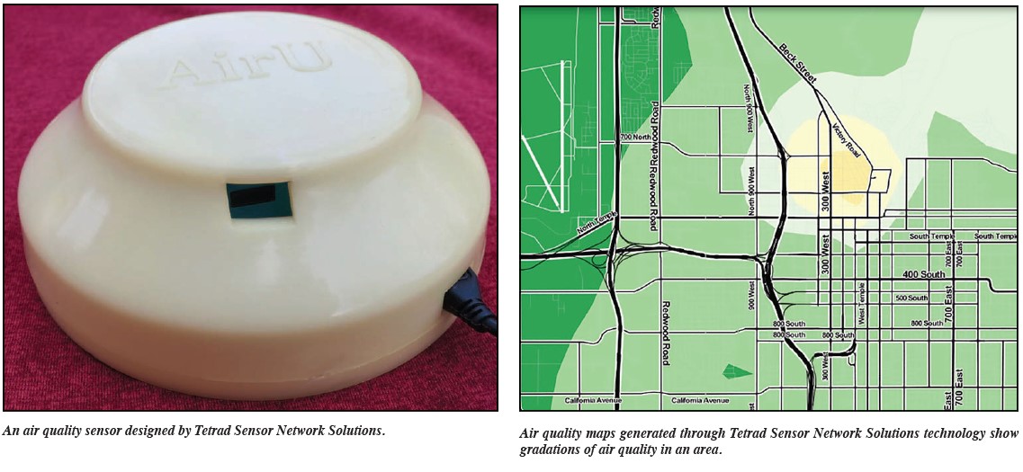
 Tetrad grew out of a project conducted by four faculty members at the University of Utah. Through the project, air quality sensors were developed that are low cost and can be networked together to create a comprehensive picture of air quality at a neighborhood scale. Because the sensors are low cost, it is easier for a city to place many of them around the community.
Along with this hardware, however, the team developed software that evaluates the data while taking into consideration factors such as altitude, which can greatly affect air quality. It then presents the data in a more understandable way than the simple colored dots presented in other air quality software.
Instead, Tetrad’s AirViewer presents the data in a way that looks more like a heat map, with a gradation of colors indicating exactly what type of air quality neighborhoods are experiencing. There is only a 15-minute delay in the data shown, meaning users can see an extraordinarily dynamic and accurate representation of the air quality in their area.
“Our project was about developing a sensor network and then developing strategies for improving data quality and then helping people to interact with the data,” said Kerry Kelly, co-founder of Tetrad Sensor Network Solutions and an assistant professor of chemical engineering at the UofU.
This original project was funded through a grant from the National Science Foundation and included work by Pierre Gaillardon, Tetrad’s other co-founder and a UofU associate professor of electrical engineering; Ross Whitaker, UofU professor of computer science; and Miriah Meyer, UofU associate professor of computer of computer science.
“We thought we had a good twist on this where we were looking at both data quality and being able to put out large networks of sensors and help people understand pollution at the neighborhood scale,” Kelly said.
The team placed about 100 sensors throughout the Salt Lake Valley and learned that air quality is a lot worse in areas with lower elevation. Also, fireworks pollution tends to stay in the valley instead of traveling up to the benches.
Eventually, the team was contacted by other UofU researchers who wanted to place the team’s technology inside the homes of asthmatic children. Around the same time, US Ignite approached the team and asked if they’d be interested in expanding the technology they’d placed in the Salt Lake Valley into other areas of the country.
Tetrad was formed to fulfill these requests. Utilizing its recent grant from Utah Ignite and the chamber, Tetrad is working with three cities — Chattanooga, Tennessee; Kansas City, Missouri; and Cleveland, Ohio — to provide them with sensors and help them set up an air quality network in their areas.
In order to see the Salt Lake City air quality map, visit tetradsensors.com.
“I think our vision is every city is going to have their own map and their own app,” Kelly said. She believes air quality sensors will continue to get smaller and more affordable, perhaps to the point where people will wear them and track their own exposure to pollution.
“I’m hoping this type of information is useful, especially when we get hit by wildfire smoke, to better predict where it might be going,” she said.